Plans for mixed-use development with 516 houses submitted
A hybrid planning application has been submitted for a residential-led mixed use development next to Askham Bog in York.
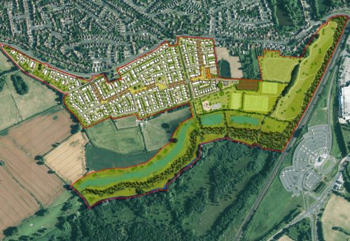
Barwood Strategic Land has submitted the application to City of York Council, stating that there would be two parts to the proposed development off Moor Lane at Woodthorpe in York.
Part A seeks outline planning permission for up to 516 residential units, a local centre up to 800 sq m, a sports pavilion up to 150 sq and associated public open space, landscaping, highway and other infrastructure and drainage.
Part B seeks full planning permission for the demolition of all existing buildings and structures, an ecological protection and enhancement zone and four new principal vehicular access arrangements.
The site extends to 98-acres and comprises of agricultural land and farm buildings at Marsh Farm. The land to the south comprises fields and Askham Bog, a site of special scientific interest (SSSI).
The application states: “The vision is to create a high quality development that respects its setting. The new development will be well integrated with the adjoining built up area but will also have a strong community feel itself, including a small local centre and various recreational uses. Its character is to be determined at the reserved matters stage although the intention is that it will have its own identity, taking
account of the local vernacular.”
The application also addresses its proximity to Askham Bog, adding: “In terms of sites of national importance (SSSI), Askham Bog SSSI is the only site requiring further consideration owing to its proximity
to the site’s southern boundary. The habitats and associated fauna within the SSSI have very little in common with those occurring within the site, however a strategy has been developed to address potential urban
edge, visitor pressure, hydrological and fragmentation effects upon the SSSI.
“Most notably, this includes a 125m wide Ecological Protection and Enhancement Zone (EPEZ) along the shared boundary with the SSSI, which separates the SSSI from both residential development and public open space and will prevent uncontrolled access into the SSSI which currently occurs along its northern edge.”


