Further progress made on £45m flood alleviation scheme
Work is continuing on a £45m York flood alleviation scheme to better protect businesses and homes from the effects of flooding, the Environment Agency has said.
Ben Hughes, project director, said: “We are doing all we can to ensure work continues as much as is feasible, and that delays caused by the knock-on effects of this pandemic are kept to an absolute minimum.
“Our priority in these difficult times is the health, safety and wellbeing of residents and staff, so we have closed our drop-in hub on Wellington Row and we will not be holding any public engagement events.
“As an organisation we are doing everything we can to support our community, our government and the NHS by abiding by these measures.”
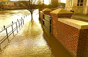
The agency recently completed work to raise the height of the North Street flood defence, which successfully handled its first test when the city suffered flooding earlier this year.
The work saw new flood gates installed, including a new wider gate to allow better flow for pedestrians into North Street gardens.
Hughes said: “This February was the wettest since records began, with peak river levels at the Viking recorder reaching 4.47m. During this time the gates and wall did their job.
“To complete this flood cell and increase the level of protection to properties in this area we still need to replace the floodgate under Lendal arch which is programmed for this September.”
Work is also due to continue on raising the embankment between Water End bridge and Scarborough Bridge, behind St Peter’s School.
Two of the flood ‘cells’ that make up the wider York flood alleviation scheme – Clementhorpe and the Foss flood storage area – are due to be heard by the local authority planning committees next month.
The Clementhorpe scheme, which will better protect 135 homes, is due to be heard by City of York Council planning committee on 9 April.
Plans include a floodgate at the junction of Clementhorpe and Terry Avenue, as well as flood defence walls at Waterfront House and Lower Ebor Street.
There will also be additional flood defences built behind Rowntree Park and the adjoining caravan park.
The Foss flood storage area would be built north of Strensall on the River Foss. It would hold back water and slow the flow back into the city in times of heavy rainfall.
Along with the upgraded Foss Barrier, this would better protect more than 1,000 properties along the Foss corridor, such as Huntington Road.
Due to the flood storage area straddling two local authorities, the planning application will be heard by both Ryedale District Council and City of York Council.
A planning application has also been submitted for flood defence work at Bishopthorpe.


